


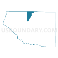
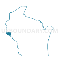
MARTELL - T 2 Voting District, Pierce County, Wisconsin
About
Outline

Summary
| Unique Area Identifier | 696147 |
| Name | MARTELL - T 2 Voting District |
| County | Pierce County |
| State | Wisconsin |
| Area (square miles) | 14.11 |
| Land Area (square miles) | 14.08 |
| Water Area (square miles) | 0.02 |
| % of Land Area | 99.83 |
| % of Water Area | 0.17 |
| Latitude of the Internal Point | 44.83181020 |
| Longtitude of the Internal Point | -92.46650170 |
Maps

Graphs
Select a template below for downloading or customizing gragh for MARTELL - T 2 Voting District, Pierce County, Wisconsin


Neighbors
Neighoring Voting District (by Name) Neighboring Voting District on the Map
- ELLSWORTH - T 1 Voting District, Pierce County, WI
- KINNICKINNIC - T 3 Voting District, St. Croix County, WI
- MARTELL - T 1 Voting District, Pierce County, WI
- PLEASANT VALLEY - T 1 Voting District, St. Croix County, WI
- RIVER FALLS - T 1 Voting District, Pierce County, WI
- RUSH RIVER - T 1 Voting District, St. Croix County, WI
- TRIMBELLE - T 1 Voting District, Pierce County, WI
Top 10 Neighboring County Subdivision (by Population) Neighboring County Subdivision on the Map
- River Falls town, Pierce County, WI (2,271)
- Kinnickinnic town, St. Croix County, WI (1,722)
- Trimbelle town, Pierce County, WI (1,679)
- Martell town, Pierce County, WI (1,185)
- Ellsworth town, Pierce County, WI (1,146)
- Pleasant Valley town, St. Croix County, WI (515)
- Rush River town, St. Croix County, WI (508)
Top 10 Neighboring Unified School District (by Population) Neighboring Unified School District on the Map
- River Falls School District, WI (22,944)
- Ellsworth Community School District, WI (11,180)
- Baldwin-Woodville Area School District, WI (8,697)
Top 10 Neighboring State Legislative District Lower Chamber (by Population) Neighboring State Legislative District Lower Chamber on the Map
- Assembly District 29, WI (66,814)
- Assembly District 30, WI (66,575)
- Assembly District 91, WI (56,636)